The Iffley History Society
|
The Iffley History Society |
|||||
|
The History of Iffley |
|
| The
Name - Iffley In the chronicles of Abingdon Abbey (941-46) the place is called Gifteleia. The Domesday survey (1086) has Givetelei. Merton College records in the 1290s call it Iftele and Yiftele; it is Yeftley to the civil servants writing up the Domesday of Inclosures, in Latin, in 1517-18; Lincoln College accounts, written less formally and in English, have Ifley by 1543, and it is Iffley or Iflie, according to how well people could spell, during the Civil War 1642-46. Clearly, the sound of the name - at a time when spoken forms were dominant - was fixed by then. Afterwards the Y survived in occasional use, but only lawyers bothered with the T. The Ley element is from a Saxon word for cleared ground, and appears again in neighbouring Cowley. Ekwall, authority on English place names, is not sure about the Saxon root of the rest; it may mean a gift, or it may mean a kind of plover. The Iffley Tapestry in the Church Hall chose to illustrate a lapwing - it makes a good picture. |
|
|
The Ground |
|
|
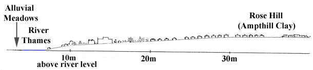
The local building stone is limestone and it was taken from the hillside. W J Arkell, Oxford Stone, records Iffley stone used at Merton College in the 1290s: Walter Merton the founder held Iffley manor. Quarrying was on a small scale. On Rose Hill the clay was used more intensively. The Victoria County History of Oxfordshire (VCH) mentions decorated iron-age pottery there, and evidence of Roman working kilns. |
|
|
Click for Topographical Anglo-Saxon map of Oxford, 95k, showing Roman Redbridge and Donnington Bridge crossings. |
|
|
The Archaeology From the Saxon period, VCH illustrates a gilt-bronze brooch with garnets, which is now in the British Museum. |
 |
|
The Domesday Survey 1086 The demesne (land reserved for the lord's own use) had one plough and five serfs (unfree peasants obliged to work for the lord). There were 14 villeins (tenants holding their land in return for agricultural labour) and six bordars (smallholders who had cleared woodland or waste ground on the edge of the settlement); the villeins and bordars had four ploughs. (The value was 100s; now £4.) |
|
 |
|
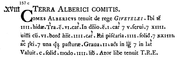
| The
Iffley section of the Domesday Book in a special type by Abraham Farley,
1783 edition. (Reproduced by kind permission from the Phillimore edition of Domesday Book, volume 14, Oxfordshire (General Editor, John Morris), published in 1978 by Phillimore & Co Ltd, Shopwyke Manor Barn, Chichester, West Sussex, PO20 6BG.) |
|
|
Back
To Top
In 1393 Iffley was confirmed in its status as a revenue-raising unit for an absentee landlord. Sir Richard Abberbury of Donnington Castle, near Newbury, had acquired Iffley as a gift from Richard II's queen; he founded an almshouse at Donnington, to be supported by the rents from Iffley. The Donnington Hospital still owns property in Iffley and was the principal landowner until after the second world war. Some of Donnington's principal tenants, however, have tried to benefit their small community of farmers, carpenters, masons, shoemakers, millers, servants, labourers and paupers. |
|
|
The Location of Iffley,
the Water Mill, the Fishing and the Ferry It is likely that the hill, running to 295 ft, now known as Rose Hill and Iffley, was a desirable place to live, safe from any floods. Many other villages, above and below, are set back from the river to cater for floods. A water mill was built in the mid-11th century and it survived for almost 800 years. Originally owned by a series of Oxford burgesses, it was bought in 1445 by Lincoln College, Oxford, who owned it until it was destroyed by fire in 1908. It ground malt, barley, corn and other cereals and became a fulling mill for a short period in the 15th century. It was notorious for its arguments between bargees and millers, who being in possession of the lock, whether it was a flash or pound lock, could preserve his head of water, and not let it flow down river, by opening his gates, as long as he wished. The mill was picturesque and much painted, sketched and photographed. By the end of its life, better transport, canals, roads and railways, had its impact on its viability and money spent on upgrading the machinery was too late and probably too little. The fishing rights, which went with the mill and were owned by Lincoln College, extended from 300 yards below the mill to the mouth of the River Cherwell, a distance of almost two miles. The most prized catch were eels, which were a delicacy. The lock gates incorporated eel traps. There was a ferry boat, but it was not a regular ferry crossing. Adjacent to the lock was a landing place where it was normal to land coffins, as a bye-law prevented coffins being carried across the lock. |
|
|
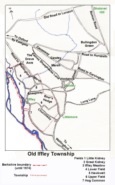
Old Iffley
Township
Connecting routes, boundaries and township fields before enclosure. |
|
|
|
|
|
The ecclesiastical parish boundaries were as the township, except that Hockmore Street in Cowley was a detached part of Iffley parish. It was also customary for Littlemore people to use Iffley church, since much of Littlemore was a detached part of an Oxford city parish. Names from Cowley and Littlemore are frequently found in Iffley parish registers. Parish boundaries were rationalised in the nineteenth century and again in the 1980s. |
|